On my birthday I have started a tradition. I go hiking! Since I love hiking and the desert outdoors is the place to be, I was found rambling the desert countryside and up a mountain. My hiking destination was Picketpost Mountain. Rather meager mountain only boasting 4300 some feet; however, one does not let the elevation of desert mountains be the judge. The character which shapes the mountain is found instead along the trail of rocks, desert flats, bajadas, and the various species of plants (cacti, succulents, desert trees, shrubs, and wildflowers).
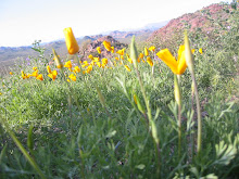
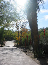
Roughly the first mile and quarter is navigating through dense chaparral which is defined by shrubs, trees, and cacti. Some plants including mesquite, palo verde, jojoba, ocotillo, creosote, cholla, Saguaro, and prickly pear were the most prevalent identified genres found. I had fun stopping occasionally in search of jojoba nuts and admiring the different plants along the trail.
So, finally I come to the base of the mountain where the trail starts to lead upward quite so. This is where I had a long break making sure I was still hydrated and ate some food. And studying the trail description and study the mountainside to visually map my route that I would be required to take. It clearly becomes evident that the trail up the mountain is for no wussies. The slope up to the base of the cliffs is complied of rocks, big boulders and thorny vegetation. A hike like this becomes rather technical. Where the mind works out strategies and moves.

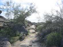
And thus I commenced up the rocky terrain leaving the visible trail behind. Besides my trail description, one becomes attuned to the minute details of the trail. And this is very vital in navigating a course such as this. There are signs on the trail the lead the correct course such as the small rock sculpture pile in above picture. Also there were red dots and some arrows. But in the end some places required old fashion route finding skills of studying with trial and error. What is important in a terrain as such, I memorized the details of specific rocks and plants. This proves to be important as so when coming back, one is able to identify the correct passage or turn without going astray off down the mountainside. Or as four hikers ended up doing, straying on a ledge far off course. I had to direct them off the ledge and back onto the trail.

The trail continues to become more steeper and climbing over and up boulders.

The real challenge begins. I am on the mountain itself. The passage hugs the narrow ledge along the base of the cliffs and then up the narrow chute to a wall of rock face stretching many feet up. The above picture is indeed the route up the mountain. This is where the route becomes technical as I climbed and found places for foot and hand holds. It was not as bad as one thinks from appearances, but still, a wrong move could prove to be disastrous. And vertigo is not an option to have. Keep your eye on the immediate work at hand and don't look down.

After the ledge, chute, and rock face, I come to another passage of rather steep switchback slope that leads to the mountain top. It is steep and gravelly. And where I met one of my three near slides off the trail. Also the vegetation is starting to grow onto the trail in many places, such as the one above. Even if it is hard to see, the trail above is tilted at an angle and the pebbly, rocky dirt is so very slippery. In this one instance, my backpack happens to brush against the prickly pear causing me to loose my balance ever so. My foot slips off and to prevent myself from tumbling through cacti and part of the mountainside, I quickly throw myself in the other direction right into the prickly pear. My first cacti encounter where the thorns and glochids (smaller thorns) pierce through the skin of my upper leg and arm. Oddly enough the prickly pear seemed to be holding onto me, and I managed to regain balance and prevent a much scarier thorny experience. But spent hours picking out the thorns and some still could be felt a day later.

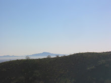
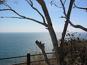
Finally after much work, the top was mastered and I got to the other side to see the vistas spreading Eastward. Magnificent vistas all around streching for miles and miles and miles. It was a perfect day weather wise as I could even see the mountain range of the Catalina's (by Tucson) rising up out of the floor of the desert (Sky Island).
I took a much deserved rest of lunch and admiration of such an incredible feat. Of course my mind always thought about the inevitable down climb. But I still had a mission to find on top of this mountain.

Yes, the mailbox. Someone has placed a mailbox atop of the mountain where hikers can sign in, some first aid, and other pieces of mementos people leave behind. I sign in.
I enjoy the circling hawk soaring above me and then out, out, out towards the horizon. My spirit animal has visited me and my spirit soars with it.
 On a bright and early morning, where the city still slept and the coyotes were yipping and howling on the fringes of the shadows and light, I stood huddled with a cup of hot chocolate awaiting to greet the rays of the dawning sun.
 It was a special day as I checked my gear and loaded my pack. For the day brought the beginnings of a trek, the journey of traversing the entire National trail of South Mountain - 15.5 miles over the two ranges to meet the third range at the end of the trail. The trail started at Pima Canyon dirt road which led to the beginnings of the trailhead of the National Trail.
 I started at a good pace and kept it steady throughout the trek. The trail is not difficult but the terrain changes going up hillsides, over rock boulders and desert pavement. The first part of the trail I have traversed many a time on smaller hikes when at South Mountain. On those hikes, I make a loop trail with the National trail and Mormon trail and visiting hidden valley among the rocks.
 And on the trail continues.
 I made several stops to hydrate, pause, and snack on energy foods. It is especially important to keep up with the continual energy so I may last for the entire trek and keep healthy. There are many people who came to participate in the National trail trek day. Many setting their own goals. It is no competition just a way to marvel at the beauty of it all and accomplish in the personal feats one pursues in such a journey as this.
 At about 7.9 miles, I reach the halfway point by Telegraph pass. The views of the home stretch are in view but yet still many miles to go. At the halfway point, there is a stop where food for lunch is served for the hikers. I had started 7:40 and arrived at Telegraph pass at 10:30. I relish the much enjoyed sandwich and huddled close to the ground in my windbreaker. Even though it was clear and sunny with the clouds on the horizons and passing over, it was very windy with temps in the 50s. However, it is a perfect day for a ramble.
 And so with still 7.6 miles yet to travel, I start again. Upwards I go onto the Gila range to where I spent most of the remaining miles traversing across the Gila ridgeline. The views are picturesque and sometimes I pause wondering just where am I. I seem to be in a place so far away. Or rather have stepped back into time crossing the dusty floor of years and years and years of change.
 On a journey as a long as 15.5 miles, one must wonder what does one do to occupy time? Besides the obvious physical movements of stepping with one foot and the next and the next and the next. The mind comes alive or does it? I find my mind becoming quiet. Thoughts come and go but never remain too long. I find something deeper as I seem to go deeper and deeper. There is a rhythm in my walking and something in me finds balance, a tune to follow in step. For there is a tune within. It is song that is sung at the end of the movie, Never Cry Wolf (based on the Farley Mowat book, Never Cry Wolf). It is scene at the end of the movie where Farley and an old innut gentleman traverse a long ridgeline in the high altitudes of Alaska. It is that tune I hear whispering and dancing as I follow the trail.
 For all else falls away, the daily toils of work and worries seem to hold no ground here. There instead in the emptiness of it all I am one, in being with myself, harmony. Joy and majestic just as the vistas unfold. And the journey unfolds. One step, two steps, always a step into the unknown.
 And so the last roughly two miles crosses the wash and valley between the Gila range and Ma Ha Tuak range where the day's journey will end. The last mile is the longest mile I have ever walked. Never a mile was as long as this. Each moment felt, each rock I touched. The present moment unfolding into the new present moment seemed like an eternity from moment to the next. And who knows, perhaps a lifetime did pass as each moment came and went.
 And rejoice. I finally arrived to the journey's end. I had completed the breath of the trail in five hours and 30 minutes. Much faster than originally anticipated for seven hours of hiking. I sat down while the park rangers were busy bustling to and fro and looked back from hence I come. Indeed it is the journey and not the destination that is the true goal. My feet are tired and it was good to unload my day pack. But my spirits elated with calm, quiet peace. I had arrived home.